Structural studies on Gyajo Glacier in Khumbu region, east Nepal
本報告では、東ネパールのクンブ地域にあるギャジョ氷河の構造に関する下記論文から、現地調査の結果をまとめた前半部分を紹介します(実験的研究の後半部分は省略)。
氷河上流部分に降った雪が氷河氷になり、氷河流動の過程で、氷河の構造がどのように変化(変成)するのかを調べました。世界の山岳地帯で見られる片麻岩などの変成岩の構造と氷河構造との類似点は、岩石や氷河研究者が従来から注目しています。
記
ON PREFERRED ORIENTATION OF
GLACIER AND EXPERIMENTALLY DEFORMED ICE.. 1972, JOURNAL OF GEOLOGICAL SOCIETY OF JAPAN, 78, 12,
659-675.
Plate1 東ネパールのクンブ地域にあるギャジョ氷河の構造
Structural studies on Gyajo Glacier in Khumbu region, east Nepal
1. Introduction
The present author engaged in the investigations of
the structural glaciology at Gyajo glacier in the Solu-Khumbu district of East
Nepal from June to December in 1970 (Fig. 1).
The summer monsoon season, which lasts from June to September in East Nepal, brings
rain falls to the Himalayan highland below 5400 m above sea level. The rain turns into snow
fall above this level. During the season of 1970, the amount of snow accumulation
reaches up to 4 m which is ten times that of the other whole seasons approximately. It should be
noted that the snow accumulates mainly in the summer season and
develops to glacier ice in the Himalayan highland.

The mean temperature during the summer monsoon is
about O°C at near the glacier tongue. In day time, the temperature goes up above the freezing point and then the snow thaws. On the contrary, the temperature comes
down below the freezing point in night time so that it freezes up the melted water. It is,
therefore, clear that there is an apparent difference in the firnification between the Gyajo glacier and the glacier
in the polar regions where the snow metamorphoses to ice without
melting. The Gyajo glacier should be classified into the temperate
glacier.

This glacier has an area of 1 km by 1.5 km and its terminus is situated at 5230 m above sea level, while the highest point of the accumulation area is at 5650 m (Fig. 2). In the present report,
the accumulation
area above 5420 m is defined to be the upper-stream, and the ablation area to be the down-stream. The midstream between the upper and the down-stream is steeper than
other areas. A line which
connects every center of traverse sections is named the center line. Through the firnification, the snow turns into ice of which the grain size ranges 2 to 4 mm. The fine ice in the upper-stream flows down to the downstream and it grows into large ice crystals of more than 70 mm in grain size (Fig. 7). The present author has kept particulary interest in the relation between crystal growth and
preferred orientation of the crystal axis of ice as the glacier flows down.

In order to measure the surface flow, forty
three stakes were set up and a base line was settled at X and Y points on the left bank of the glacier (Fig. 2).
2. Structure of Gyajo Glacier
Bubble foliation is defined by the alternations of bubbly ice and bubble-free transparent ice layer which is strongly developed in the down-stream near the left bank of the glacier (Fig. 3, 6, 9). Stratification is represented by thin layers marked by fine sands, deposited by strong wind which occurs twice a year; once in the pre-monsoon season and the other in the post-monsoon season. There are two kinds of bubble foliation, one of which developed at the upper part of the glacier, has the strike parallel to the flow direction with steep inclination towards the center line. The other occurs at the lower part of the glacier which is able to be observed only at the terminus, and it has not much bubbles but is marked by the thin layers of fine clay and sand which
are resulted from the intense
shear movement, which brings fine clay and sand out of the bed rock. (Figs. 3, 6, 11).

The structure of the stratification at the upper part in the down-stream shows either gentle
or complicated fold
system, while it reveals to be intense shear
movement parallel to the bed rock to produce the foliation above
mentioned at the lower part. Then, joints which signify closed fractures and open to be crevasses, which develop within the upper part of the glacier and hardly cut down to the lower part (Fig. 5, 10). A thrust fault divides
the upper part and the lower in the glacier. Consequently, the
structure of the glacier is vertically divided into two structural units which should represent the structural
levels.

The stratification in the down-stream shows the fold-axes parallel to the flow direction with gentle undulation at the surface, while the acute and complicated fold system such as recumbent and slip folds, develops down to the lower structure (Figs. 4, 6, 10, l l). Furthermore,
another fold system,
which is partly observed in the downstream, has the fold axis normal to the direction of the glacier flow. Such a superimposed
fold system is never
seen in the upper- and the midstream (Plate 1).

The average grain size in the upper-stream
is 2 to 4 mm and grows to be 70 to 80 mm in the down-stream and 110 mm in the lower structure (Plate 2). The ice crystal becomes
especially large near the
left bank in the down-stream (Fig. 7). The shape of the ice crystal is not polygonal in the mid- to the down-stream and generally has two elongated directions on the horizontal
plane. The strongly
elongated direction is parallel to that of glacier flow, but the weak one is normal to the flow direction (Fig. 8 and Plate 2).
In the ice of the upper-stream, fine and circular bubbles are homogeneously scattered
but it becomes large and is more elongated toward the down-stream. The elongated direction of bubbles is parallel to the direction of glacier flow (Fig. 9).
The glacier surface in the
upper-stream flows six times faster than that in the down-stream does during the
summer monsoon season. The maximum flow velocity is 1 18 m y-1 in the upper- stream and 18 m y-1 in the down-stream
(Fig. 12).
3. Fabric Pattern of Glacier Ice
The locations for measuring the orientation of the crystal axis of ice are F7, J5, H0, F3, F0, D0, B0, B3, F4, and B4 (Fig. 2). F7, J5, H0 and F3 belong to the upper-stream, F0 and D0 to the mid-stream. B0 and B3 belong to the down-stream with weak bubble foliation. F4 and B4 are obtained from the down-stream with strong bubble
foliation. Each sample was cut out parallel to the stratification plane. And also the ice samples were cut out horizontally at an ice cliff of the glacier terminus. The ice crystals were divided by the grain size into two groups; smaller and coarser grains, and the crystal axes of 100 ice grains are measured out of each ice sample. In this report,
the orientation diagrams of the crystal axis plotted on the lower hemisphere of SCHMIDT net is called "fabric pattern". The great circle
girdle drawn on the fabric pattern indicates the bubble
foliation plane.
3-1. Fabric Pattern of the upper-stream
In this part, the fabric pattern shows no particular preferred orientation but a great circle girdle is seen perpendicular to the bubble foliation plane at J5 and F3L. The mean grain size is 2 to 5 mm and the texture of ice is generally polygonal (Fig. 13 and Plate 2). The bubble foliation is not well developed.
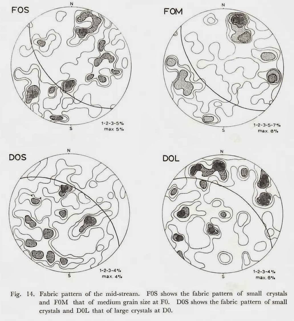
3-2. Fabric Pattern of the mid-stream
In this part, the fabric pattern of the coarser crystal grain gives a small circle
with several maxima centered at the pole of the bubble foliation (FOM and DOL), but that of the smaller crystals shows the similar pattern to those of the upper-stream
which shows the great circle girdle perpendicular to the bubble foliation plane (FOS) . The grain size reaches up to 40 mm (Fig. 14 and Plate 2).
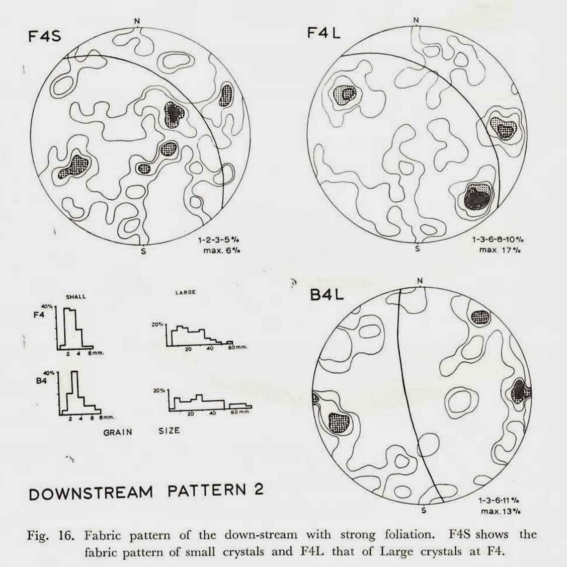
3-3. Fabric Pattern of the down-stream
The fabric pattern with weak bubble foliation shows no clear preferred orientation (Fig. 15), but that with strong bubble foliation gives clear
preferred orientation with three maxima (Fig. 16). There is a difference between the fabric pattern of coarser grains and smaller ones; the former has strong
concentration in maxima (F4L, B4L), but the latter shows the great circle girdle normal to the bubble foliation plane (F4S). The maxima of the pattern from the coarser grain distribute on a smaller circle of which the center
coincides to the pole of the bubble foliation plane at location B4. The crystal grain then grows up to 75 mm (Fig. 16).

Both of the fabric patterns of the upper structure with complicated fold system and of the lower structure,
give very strong preferred orientation with maxima. The fabric pattern of the lower structure (TL) has a tendency to concentrate into single maximum on a small girdle of which
the center situates at the pole of the bubble foliation plane (Fig. 17). The ice crystals of the lower structure are immensely elongated to be 110 mm along its spindle axis and the
crystal texture of fine grains are cataclastic
(Plate 2).
Plate 2 氷河氷の結晶形を示す薄片写真(ギャジョ氷河で撮影)